A straight forward walk today starting from the centre of Keswick. An ideal walk because of the changeable weather as it gave us the option to continue on to Bleaberry Fell or just complete a circular walk to Walla Crag. In the end the weather settled and Bleaberry Fell, being not much further on, was too much of a pull to ignore!
WAINWRIGHT BOOK: The Central Fells Book 3
DIFFICULTY: 2 WALK LENGTH: Half day
DATE and START TIME: Tuesday 11th August 2015 am.
PARKING: Any of the carparks in Keswick.
ROUTE WALKED: Keswick – Moot Hall (in the market square) – St John’s Street – Old Ambleside Road – Springs Road – Springs Farm – Springs Wood – Rakefoot – Brockle Beck – WALLA CRAG – BLEABERRY FELL summit – and back – refreshments at Abraham’s Cafe in George Fisher’s Keswick.
HIGHEST POINT: Bleaberry Fell – 590m/1932ft.
WALKED WITH: Pal and Mila (aged 12).
WEATHER: Cloudy day with outbreaks of rain on the ascent.
From the centre of Keswick we walked up past our favourite outdoor shop in Keswick, George Fisher’s, then along St John’s street which before long becomes the Old Ambleside Road. We took the right hand turning into Springs Road passing beyond Springs Farm and then into Springs Wood. Through a gate and starting to head up alongside the gill and we’re soon out into the open with rather hazy views of the North Western fells – shame about the low level clouds. Derwent Water is where the 2016 film Swallows and Amazons was filmed (you can tell I’m still catching up on posting our walks from way back). – On a clear day the views would be magnificent – but it won’t spoil our enjoyment!

The views quickly open up once we get out of Keswick.
On the left beyond Derwent Water you can see Maiden Moor, then Hindscarth beyond. Following the ridge down from Maiden Moor you come to Catbells. The most obvious fell on the right is Rowling End leading to Causey Pike with its distinctive bobble summit, visible despite the clouds.

Looking further west you can see the Newlands Valley with left to right: the end of Catbells (Skelgill Bank); Rowling End leading to Causey Pike; Knott Rigg leading to Ard Crags; Whiteside; Wandope; Eel Crag; Causey Pike in front. The triangular summit is Outerside; Barrow to its right with the two large pale patches on it. Beyond is Hopewell Head with the highest summit being Grisedale Pike.

Not a great photograph but hey ho – it’s our first view of Walla Crag on the left and opposite you can again see Hindscarth with Maiden Moor in front and the ridge route leading to High Spy.

Here’s Mila heading up through Springs Wood.
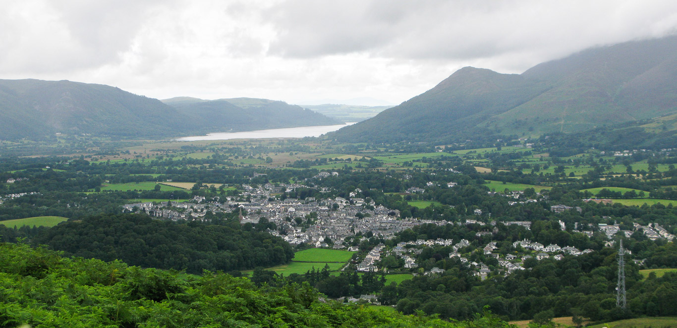
Keswick below us now with Bassenthwaite Lake beyond. On the right you can see the Northern Fells with Dodd being clearly visible and further to the right is the rest of the Skiddaw Massif lost under low cloud.

Again, not a great photograph but it shows both lakes – Derwent Water on the left with Bassenthwaite Lake on the right. Portinscale is at the head of Derwent Water with the fells in the background being Whinlatter Fell; Lord’s Seat and Barf and Sale Fell.

Pal and Mila following the clear path up to the summit of Walla Crag. The heather is covering the fell with a beautiful mauve blanket.

There are four main islands (a fifth floating island appears sporadically towards the end of the summer) on Derwent Water all now owned by the National Trust. St Herbert’s Island is the largest and is beyond Rampsholme island the smallest island. St Herbert’s is the largest island being between 4-5 acres. It’s named after Saint Herbert who is said to have brought Christianity to the area in 685 AD. The island was used as a hermitage and after Herbert died became a place of pilgrimage. Though I’ve never visited the island the National Trust website says you can still see St. Herbert’s cell amongst the undergrowth. I know the island from the well known children’s book by Beatrix Potter, ‘The Tale of Squirrel Nutkin’ where it’s known as Owl Island. The squirrels on their twig rafts sail across to visit the owl, Old Brown, giving him a gift and asking permission to gather nuts on the island. You’ll need to read the book to find out what happens to poor, cheeky Squirrel Nutkin! . . . Boat users are allowed to land on the island.
Rampsholme Island is the smallest of the four islands with its name being derived from the Old Norse meaning ‘wild garlic island’ a suitable name considering the abundance of wild garlic growing on the island.
Lord’s Island is close to Derwent Island in the inlet formed by Friar’s Crag . It was once the residence of the Earls of Derwent Water until the Jacobite rebellion although the house is now gone you can still make out its foundations. Local legend says that the Countess of Derwent Water fled the house after the arrest of her husband for his part in the Jacobite rebellion 1715. According to the legend she was carrying a fortune in jewels which were lost during her mad ascent of a cleft on Walla Crag, giving rise to the name “Lady’s Rake”!
The only inhabited island is Derwent Island close to the boat landings and to the west of Friar’s Crag. It was owned by Fountains Abbey and used by the monks until the dissolution of the monasteries when it became the property of the Crown in 1539 by 1569 it was the home of German copper miners working in the area. In 1778 Joseph Pocklington bought the island and had a house, boathouse, fort and battery and even a folly built. He held annual regattas on the lake when he would fire off his cannon and used the small fort for mock battles! Over 200 years later these regattas have been revived by the National Trust and have become a very popular annual event!
There are also a number of smaller islands: Park Neb, Otter Island and Otterbield Island.

Great views for such a straight forward walk despite the low cloud.

You can see how wet it’s been – we’re well prepared with our waterproofs – but luckily for us the heavy showers seem to be coming to an end! You can just see the house on Derwent Island if you look very carefully.

Catbells was one of the first fells we climbed and is always a great choice despite its popularity.

If you look extremely carefully towards the wooded area (to the right of Barrow) in front of Swinside you can see Lingholm House nestled among the trees. It has a tearoom overlooking the rebuilt walled gardens that featured in Beatrix Potter’s stories. It looks like a great place to visit and is only about 35 minutes gentle flat walk from Keswick – they even have a free car park!
Keswick and the Northern Fells behind with Sale Fell on the far side of Bassenthwaite Lake and beyond Bassenthwaite you can just about see the Scottish hills.

The true summit of Walla Crag is further back . . . but everyone goes near the edge to enjoy the view!

Panorama west to north (taken from Lakeland Fellranger ‘The Central Fells’ Mark Richards -Cicerone Press).

There’s Portinscale on the left then in the background is Barf, Sale Fell and then Scotland!

Here’s another photo of the High Spy, Maiden Moor and Catbells ridge.

Panorama south to west (taken from Lakeland Fellranger ‘The Central Fells’ Mark Richards -Cicerone Press).

Mila with St Herbert’s Island and the smaller Rampsholme island behind her and the North Western Fells beyond.

Looking again towards Keswick and the Northern Fells, the Skiddaw Massif – it’s a shame the low lying clouds are hiding the summits! What you should be able to see is Dodd (almost the only summit clearly visible); Longside; Carl Side; Skiddaw; Skiddaw Little Man and Lonscale Fell with Latrigg in front.

This time still looking north but further to the right (north-east) you can see Latrigg with Lonscale Fell behind. The dip is Mungrisdale Common further to the right is the southern front of Blencathra – well, to be specific you can see Blease Fell, one of five buttresses which lead up to Blencathra’s summit.

Blencathra above and the Skiddaw and Blencathra in the photograph below.

Here’s a clearer view of the Northern Fells with the Skiddaw Massif on the left and Blencathra on the right with Mungrisdale Common between them.

The old Monster Munch . . . got to be included! Mila loves them so we usually have them as part of our pack lunch but we only ever have them on holiday in the Lakes, not quite sure why that is – they’re a real reminder of childhood novelty crisps!

Mila enjoying a bit of peace and quiet as she tucks into the rest of her pack lunch. What a view to enjoy!

As the weather has improved we decided to continue our walk to include Bleaberry Fell, you can see the clear path that we followed, Pal letting us know it’s time to start making a move though it’s hard to drag ourselves away from the views.

A straight forward route up through the bracken – luckily there’s a nice grassy path to walk along.

I’m not sure what weather conditions Mila is expecting but she looks ready for the worst and by the looks of things she’s borrowed Pal’s walking stick -so she’s really planning ahead.

The heather feels all bouncy underfoot and does look like a beautiful rich carpet across the surface . . . there’s Blencathra ahead.


Panorama west to north (taken from Lakeland Fellranger ‘The Central Fells’ Mark Richards -Cicerone Press).
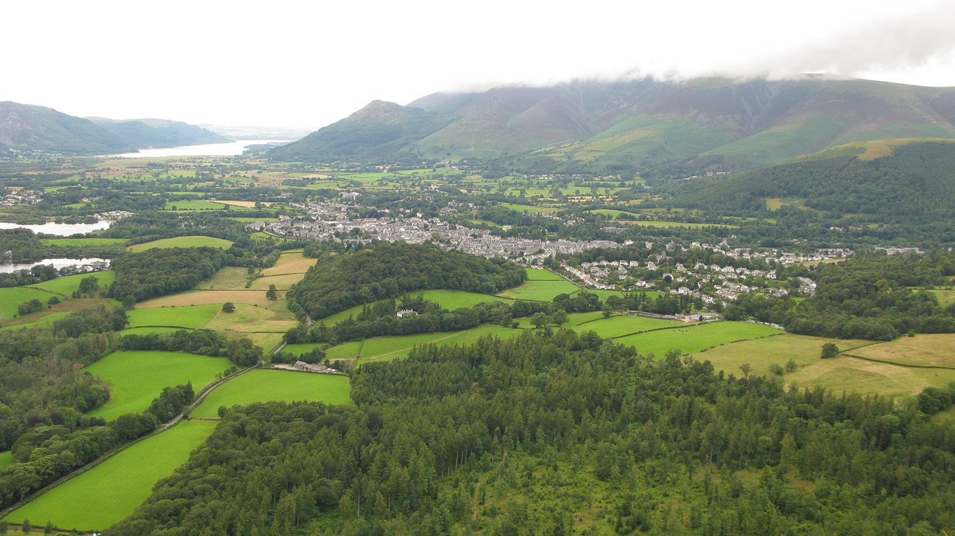
Looking back, unusually Mila is behind us – though she’ll definitely be in front of us on the descent as she’s like a mountain goat and really speedy. You can see the path we’ve followed from the summit of Walla Crag and the Skiddaw Massif beyond.

Almost the same photograph as the one above but this time you can see the two lakes of Derwent Water and Bassenthwaite Lake and the North Western Fells on the left and some of the Northern Fells on the right.

The muted colours of the photographs here don’t really capture the beauty of the scenery as we saw it which is a shame but hopefully it will have whetted your appetite to visit for yourself.

An easy route up so far . . .

Unfortunately the cloud is still making the views hazy but Mila’s starting to take off some of her layers so the weather must be taking a turn for the better.

As we’re walking the North Western fells and Derwent Water are frequently in view.

. . . Now comes the steep part as we head towards the summit . . . like an immense stone staircase ever upward . . . well, not that far and we’re at the summit!

Mila looking justifiably pleased with herself as she ‘bags’ another Wainwright summit.

Definitely time for a little sit down and time to enjoy the extensive views. Surprisingly we saw very few other walkers, probably the earlier rain had persuaded some to leave their walk to another day.

Isn’t this spectacular! Enough with the photos mum!

From here you have a fabulous view of the fells surrounding Derwent Water.


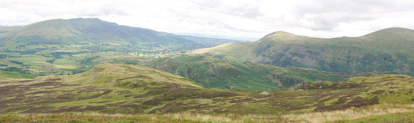
Panorama south west to west (taken from Lakeland Fellranger ‘The Central Fells’ Mark Richards -Cicerone Press).

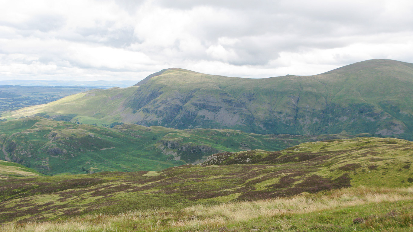
A close up – looking south.

Looking north east.
Looking east with Clough Head, Calfhow Pike and Great Dodd.

Blencathra.

Panorama north to east (taken from Lakeland Fellranger ‘The Central Fells’ Mark Richards -Cicerone Press).


Mila waiting for the ‘Oldies’ to catch up!

Looking back up towards Bleaberry Fell with the path very clearly visible on the right.

Almost back to the woods now and Mila has taken out her plaits!

The end of this walk reminds me of the great children’s book, ‘We’re going on a bear hunt’ by Michael Rossen . . . ‘Uh- uh! A forest! A big dark forest. We can’t go over it. We can’t go under it. Oh no! We’ve got to go through it! Stumble trip! Stumble trip! Stumble trip!’ Then at the end of the story when they’re escaping from the bear they run ‘back through the forest! Stumble trip! Stumble trip! Stumble trip!’ We’re nearly back to where we started . . . not much further now.

Drinks all round as we enjoy our usual haunt in Keswick – Abraham’s Cafe in George Fisher’s. A great way to end the walk and rest our weary legs.

An ice cube with a hole in it . . . what could be better!