Castle Crag is the smallest of Wainwright’s 214 fells – but it didn’t feel that easy when we walked it, and I agree with Wainwright that it deserves more than just a paragraph at the end of the chapter on its parent fell – ‘High Spy’ (also known as Eel Crag, Lobstone Band and Scawdel Fell). Wikipedia describes its ‘impressive appearance’ and its ‘rugged height apparently blocking the valley of Borrowdale, which is squeezed between Castle Crag and Grange Fell, its neighbour on the other side. This narrow gorge is known as the “Jaws of Borrowdale”‘. Wainwright described this area as ‘the finest square mile in Lakeland.’
WAINWRIGHT BOOK: The North Western Fells Book 6
DIFFICULTY: 2/3 WALK LENGTH: Half a day
DATE and START TIME: Sunday 14th August 2016 Start time 9.30am
PARKING: (MapOS OL4). Rosthwaite National Trust carpark, Borrowdale, Cumbria, UK (NY257 148). There are also a number of parking spaces adjoining Rosthwaite Village Hall (NY258 148).
ROUTE WALKED: Rosthwaite – lane towards Yew Tree Farm – Flock-in Tea Room – New Bridge – High Hows Wood – quarry caves – CASTLE CRAG summit – and back down via Lingy Bank – New Bridge – Flock-in for refreshments before returning to the car.
WALK DETAILS: 5.2 miles, 4 hours 26 mins (including lots of stops and lunch).
HIGHEST POINT: Castle Crag – 290m/951ft.
WALKED WITH: Pal and Mila (aged 13).
WEATHER: Cloudy but warm.
We took a rather circuitous route to include a visit to the quarry caves then continued up through the woods – needing to scramble up some steep patches at times. Then onto a fabulous ridge viewing area with not a soul in sight apart from rock climbers in the distance. From here we followed the path up hoping to join the path to the summit but the path we were on was obviously a sheep trod and led to a sheer drop with the path we wanted being tantalisingly close but impossible to reach. So, we had to retrace our steps back to where we had originally veered off to rejoin the main path to Castle Crag.

The Rosthwaite National Trust car park is on the right in the photograph above. When leaving the car park turn right – not left as we did at first! Then head up the lane towards Yew Tree Lane.


Our walk took us past Rothwaite’s Yew Tree Cottage. Outside is an inverted tree stump with a wonderful moss garden full of miniature models of animals and fairy tale characters.

Past the Flock-in, luckily open for refreshments later!

This slate plaque was on the wooden doors next to the tea-room.

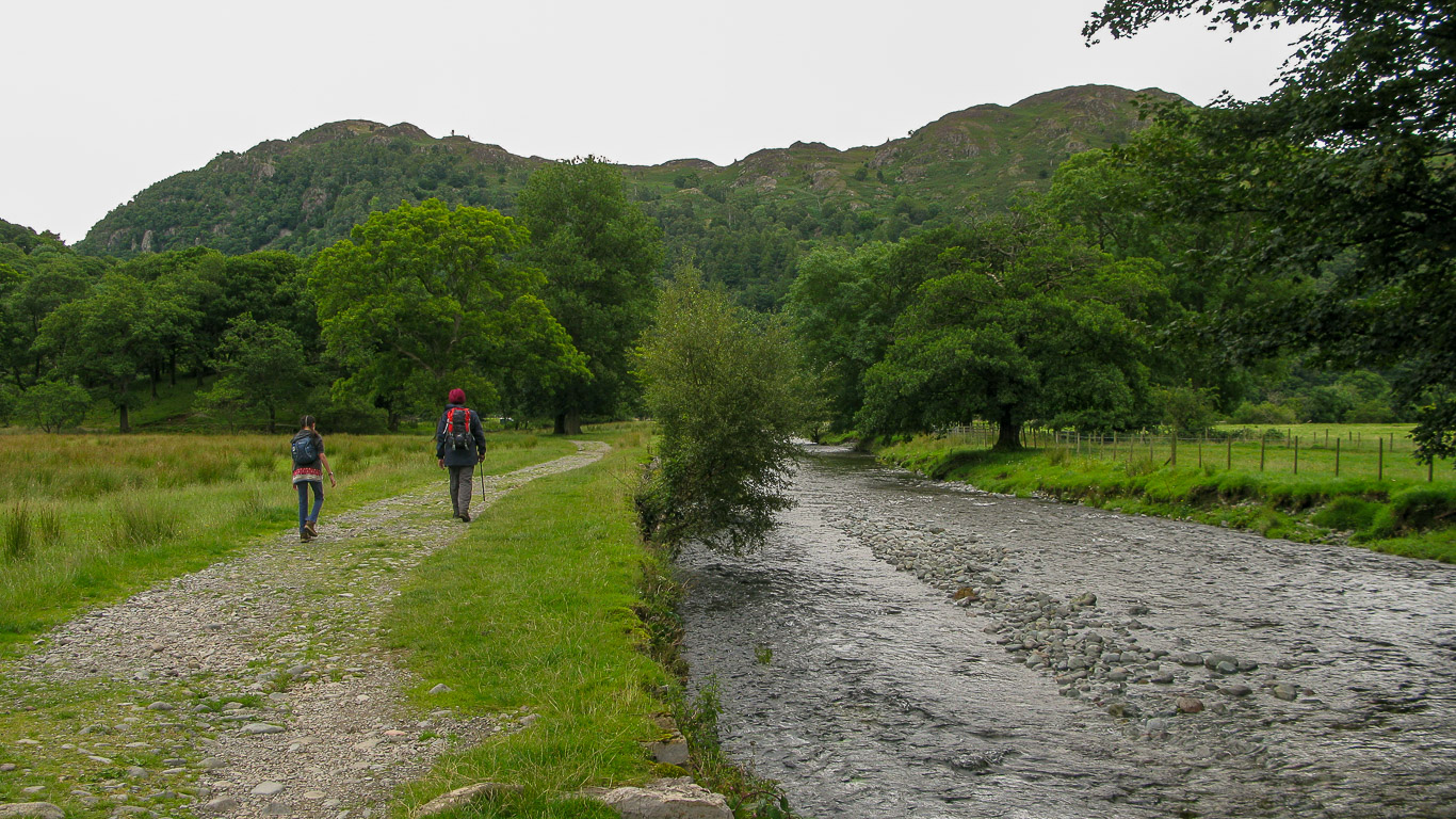
Mila and Pal, along the lane by the farm . . . with High Scawdel behind on the left then Tongue Gill and Low Scawdel on the right.

. . . and there’s a rarer photograph of Mila and I. I’m usually the one taking the photographs.

Looking across the field to the slopes of High Spy and Goat Crag (or Gate Crag) with the wooded Castle Crag on the right of the photograph.

Just follow the track . . . Mila already running – so much energy!

Is this Knotts or Great Crag across the field???

Mila was very tempted to cross by the stepping stones – despite the central stones being under water . . . but in the end we all decided to cross by ‘New Bridge’ – not much further along.

The stepping stones do look very inviting . . . but I suppose it wouldn’t do to have wet feet right at the beginning of the walk!

Having turned the corner Castle Crag – our goal for today’s walk – is now in front of us.

There’s Castle Crag on the left and King’s How on the right. King’s How is the best known of the three main summits on Grange Fell; the others being Brund Fell and Ether Knott (now known to be the highest point on the fell).

Here’s New Bridge – which was having work done to it – hence the red barrier on the right of the photograph. It doesn’t look very new does it? This single stone arch bridge crosses the River Derwent. The river has to skirt around Castle Crag and flow through the ‘Jaws of Borrowdale’ before reaching Derwent Water itself, two and a half miles further north.

Over the bridge and the main path continues on along the river, which is the way we went. The left hand gate leads to the path up Lingy Bank which would be our return route on this wonderful circular walk.

On the left is High Scawdel (a non-Wainwright fell between High Spy and Dale Head); then the dip is Tongue Gill and on the right is Low Scawdel.
Pal and Mila waking along the side of the River Derwent with Grange Fell’s three summits: King’s How (on the left, and best known) and Brund Fell on the right. Ether Knott is the third and highest summit which is not visible.

Looking across the River Derwent towards Great Crag.

It’s so beautiful walking along by the River Derwent. Here’s Pal with Brund Fell ahead – the second highest of the three summits on Grange Fell.

Mila, ahead as usual, as we enter High Hows Wood.

One of a number of caves in the area. This is the bottom workings of the Lower Castle Crag slate quarries in High Hows wood.

The slopes of Castle Crag are extensively quarried with pits and levels on the northern and south eastern flanks; but High Hows Quarry really achieves fame as the home of the eccentric Millican Dalton.

In search of the famous Millican Dalton’s cave, we walked through the woods on the northern side to find it. The eccentric Millican Dalton was a self-styled ‘Professor of Adventure’. The caves formed his summer house from the 1920s until his death in 1947. He rejected London city living in favour of a simple life in the countryside.

Through the gap in the wall . . .

The cave is part of the old abandoned workings several hundred feet up the hillside. The photograph above is the lower of the two caves high on the hill.

You can just see the upper cave on the right.

It doesn’t look a very welcoming ‘home’ despite it being a glorious summer!

The adjacent cave at a higher level, known as the ‘Attic’ was Millican’s sleeping quarters.

Having successfully found the caves, we should then have crossed round the hill to regain the path to Castle Crag – Luckily, as you will see later, our detour was well worth it!

The views across Derwent water opening up – a view down Borrowdale and across to the Northern fells. You should be able to see Skiddaw on the left but the cloud is obliterating the summit views.

Mark Richards, in his Lakeland Fellranger series, says ‘Walkers have been tempted to wander on from the upper cavern, as an obvious path does lead right to cross the wooded ridge and there is clear evidence of intrepid scramblers completing the ascent on the north side . . . ‘ Not us though, as it was a sheer drop!
. . . See what we mean about it being a clear path . . . and why we thought it might be a way to the summit!


It’s not very obvious from the photos above but at times the path was pretty steep and slippery and hands were often needed – even Mila had to use her hands once or twice! Perhaps this should have told us that this wasn’t the right route!

“Come on Pops, you can make it!” – Mila explaining to Pal where to put his feet on this steep and slippery section.

Not long till we were out into the open again with great views and to the left we saw the perfect spot for a coffee stop!
I think this is King’s How, the best known of the three summits on Grange Fell probably because it has such a magnificent viewpoint. It was one of the first purchases by the National Trust in the Lake District (in 1910) and was named after King Edward VII as a memorial at the bequest of the King’s sister Princess Louise who was the National Trust’s President at the time.

Mmmh . . . which fell is this . . . ? Great views from where we were sitting.

A wonderfully quiet spot on quite a busy fell!

This is the path we wanted! It looked like we could walk along here to get back on to the correct path . . .


. . . as you can see the path pretty much comes to a dead end! I really didn’t fancy the prospect of trying to scramble down what looked like sheer rock with no discernible route . . . and even Mila, who is never daunted and climbs like a monkey, decided not to attempt it – very wisely!

Back the way we had come . . . It reminds me of the children’s book ‘We’re Going on a Bear Hunt’ (by Helen Oxenbury) . . . “We’re going on a bear hunt, we’re going to catch a big one; I’m not scared. It’s a beautiful day. Uh-uh grass [in this case bracken] long wavy grass. We can’t go over it, we can’t go under it oh no! We’ve got to go through it! Swishy swishy, swishy swashy! . . .


. . . Back through the forest stumble trip! Stumble trip . . .

Back down to the main path . . .

We need to be on the footpath heading for Grange not Rosthwaite.

Through the hole in the wall.


It’s such a beautiful walk through the wood by the River Derwent . . . It’s surprising how close the road is! The B5289 passes alongside the river on its way towards Keswick, the Borrowdale Road.

Either way will do . . .

Considering it is such a popular place it was surprisingly quiet as you can see . . . but wait until we get to the summit!

Across the stile following the clear path. It looks like two different days with Pal wearing his big raincoat and Mila wearing her sleeveless top!

. . . Across the footbridge.

. . . Heading in the direction of Seaitoller and Honister.

Across another smaller wooden footbridge.

How lucky am I to have two such wonderful people in my life . . .

Looking back towards Derwent Water and the Northern fells. In the other direction the path heads towards Grange and Castle Crag – our goal for today’s walk.

Heading up the path . . .

Across the stream – Broadslack Gill.

We needed to turn off to the left here as this leads through the gap in the wall up to the slate slag heap. But with my ‘great’ sense of direction we’d headed off straight ahead – in fact towards Seaitoller and Honister before realising our mistake and quickly diverting up the route shown in the photograph above.

Looking back at the way we’ve walked.

I would have liked to stop by the memorial bench and read the plaque to Sir William Hamer but as these two walkers in front of us decided to sit on the bench I didn’t fancy reading over them! While I was researching who William Hamer was I found an interesting website called ‘Stagwalks.com’ – I enjoyed reading the exploits of the writer and discovering some interesting facts along the way.
Sir William Hamer was knighted in 1923 because of his contribution to epidemiological science (that is, the reasons for and the spread of diseases). In fact this plaque is actually more of a postscript to the plaque on the summit, which I’ll explain later. William died in 1936 and in 1939 his wife Agnes gave this memorial plaque, bench and surrounding area to the nation in honour of her husband. The plaque states,
“The land surrounding the summit of Castle Crag was given to the nation in memory of Sir William Hamer M.A M.D. F.R.C.P. by his wife Agnes, whom this seat commemorates 1939”

The last section of the walk involves climbing the old quarry tailings wising a well work zig-zag path. It makes a wonderful tinkling sound as you climb. The website Loweswatercam.co.uk (a favourite website of mine) informed me that in the Keswick Museum next to Fritz park there is a complete xylophone made out of musical slates which you can actually play if you wish!

It’s quite steep but not too tricky though I imagine that if the slates were wet they would be very slippy, but luckily today was perfectly dry. If you look carefully you can see the zig-zag path heading up.

There is in fact an alternative route up to the right of the slate tailings . . .

. . . which you can just see to the right of the photograph.

Looking back down the way we’ve walked – It’s amazing to think that each of these pieces of slate have been handled by the quarrymen!

There’s plenty of evidence of the old quarry workings, Castle Crag. Here it looks like the remains of a typical stone store or shelter.

Looking down on the caves and ruins of quarry buildings far below us.

At the top of the slate spoil heap the ground levels out and it’s worth spending a bit of time enjoying the impressive slate sculptures and incredible views.

The view south. In the centre of the photograph is Johnny’s Wood and then beyond, left to right: the pointy summit is Rosthwaite High Fell; Comb Head; Glaramara with Thorneythwaite Fell leading down to the wood. Just above Johnny’s Wood on the right is High Doat.

Looking further left (east-south).

Here’s a close-up (east – south), looking back to Rosthwaite with the River Derwent snaking through the centre of the photograph. Left to right: Stonethwaite Fell (far left); then Ullscarf with Great Crag in front. Eagle Crag (difficult to discern) is in the centre of the photo. Then Sergeant’s Crag along the ridge from Eagle Crag with High Raise furthest away and on the right Bessyboot (Rosthwaite Fell).

A wonderful panorama of the view looking south to west. On the left of the photo you have the slopes of Low Scawdel which leads on to High Scawdel.

Further west, Low Scawdel and High Scawdel.

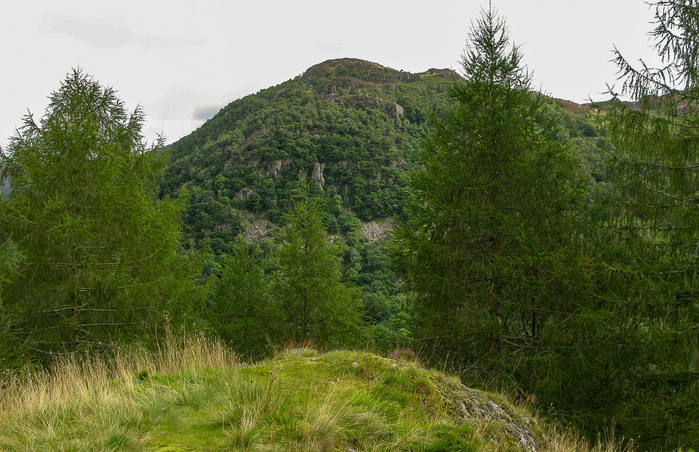
High Scawdel on the left with Castle Crag on the right.

The perfect spot for Mila to do a bit of climbing.

Great End is in the distance on the left and the clear path to Seaitoller at the base of Low Scawdel.


There’s plenty of slate to climb.

Pal and Mila enjoying the view.

Stunning views.

The standing slates make an interesting landscape on the upper quarry.

The summit of Castle Crag above.

Looking north – east across the valley of Grange-in-Borrowdale with the Northern Fells with the Skiddaw massif in the centre beyond Derwent Water and Blencathra on the right with Wallla Crag leading to the heather covered Bleaberry Fell in front and High seat. Then on either side of the valley you have Catbells on the left with the River Derwent running into Derwent Water and the summit of King’s How (Grange Fell) on the right.

As you can see the summit was pretty busy – here looking across to King’s How (Grange Fell).

The summit memorial on Castle Crag.
This memorial is from the Hamer family who donated £150 in 1920 to buy 18 acres of land on top of Castle Crag which they handed over to the National Trust, to commemorate the death of their son John who died in 1918 in the First World War. Canon Rawnsley persuaded the family to include all the local fallen from Borrowdale although there was already a memorial to them in Grange churchyard.

A close-up of the memorial plaque on the summit of Castle Crag.

Absolutely fabulous views.

Mila’s gone back down to the upper quarry area to do a bit more climbing!

We descended by the path to the side of the slate spoil heap heading for the trees.

Heading down . . .

. . . With a quick look back at the busy summit.

. . . across the meadow and down we go.

Very quiet now we’re off the summit and you can just enjoy nature and the calming tranquility of our surroundings.


A panoramic view as we descend.

. . . And there’s the gate that we saw at the beginning of our walk today . . . not far till we’re back to the village of Rosthwaite and our car.

Looking back at our route you can just about see a faint path and the gap in the wall we came through.

A final look back at the wooded fell of Castle Crag.

It feels like it’s about time for a cuppa!

It’s a short walk back to the village.

Heading past Yew Tree Farm back to the cafe we passed this morning.

“Come on Mam, time to get the drinks in . . . “

Luckily for us these walkers were just about to leave . . .

. . . Just in time for us to take their perfect spot . . .there’s also a really nice garden round the side to sit in though I didn’t notice it till I went to the loo and spotted this funny slate sign!

Another Wainwright ‘bagged’ and one that I hope we do again soon!