Mmh! How should the fell be named? Wikipedia calls it ‘Cat Bells’, it’s also two words on Ordnance maps, but I’ll stick to Wainwright’s version of the name ‘Catbells’!
I’m trying to put some of the walks that I initially put into photo albums onto my website. It’ll take me a long time to catch up with the backlog of walks and photos but I’m enjoying revisiting the old albums and remembering all the good times we’ve had together.
WAINWRIGHT BOOK: The North Western Fells Book 6
DIFFICULTY: 2 WALK LENGTH: Just over 2hrs
DATE and START TIME: Monday 20th August 2007.
PARKING: Hawes End – It’s a small parking area along the narrow lane sign posted Skelgill, 2 miles south of Portinscale, above the north-west shore of Derwent Water. This is an extremely popular spot so get there early. (NY247 212)
ROUTE WALKED: Hawes End – CAT BELLS summit – Hause Gate – Allerdale and back.
WALK DETAILS: 3.5 miles (5.6km) just over 2 hours. We had chosen a walk from the the fabulous book ‘North Lakeland Walks with Children by Mary Welsh (the photo of the route opposite is taken from the book). I really like this series as it gives me confidence
HIGHEST POINT: Cat Bells – 451m/1,481ft.
WALKED WITH: Pal and Mila (aged just 4 years).
WEATHER: A beautiful day, and Mila’s first Wainwright bagged!
The name ‘Catbells’ may come from a corruption of ‘Cat Bields’ meaning a wild cat’s shelter dating back to a time when wild cats still roamed the countryside. Wainwright (Catbells 4 in ‘The North Western Fells’ Book 6) interestingly points out that although this has been disputed, “the crags below the top on the west side have the name of Mart Bield – the shelter of the marten, which seems to lend support to the suggestion. Further, a place in the hills near Wasdale is still known as Cat Bields.” – I like the idea of it being known long ago as the shelter of the wild cat!

Our little explorer sets off . . . As you can see there’s an easy path to follow which is adjacent to the parking area which takes us up through the bracken . . .


A we walked up the path it soon narrowed as the engineered path gave way for a short time to a narrow path bordered by tall bracken. Mila gives a quick look back before continuing along the path.

. . . It’s not long before the views start to open up. There’s Barf in the centre of the photograph in the distance with the wooded slopes of Swindside on the right.

A beautiful view of Barrow in all it’s glory as we head up Skelgill Bank.

Keswick in the valley and the Northern fells in the distance with the summit of Skiddaw hidden in cloud. If you look carefully at the bottom of the photograph above you can see the narrow lane which was sign posted ‘Skelgill’; we turned right into this lane parking in the small parking area Hawes End (just out of sight in the photograph).

Looking further round to the right (east) and we get our first views of Derwent Water with Latrigg just left of centre with the Northern fells beyond with Blencathra to the right of Latrigg.

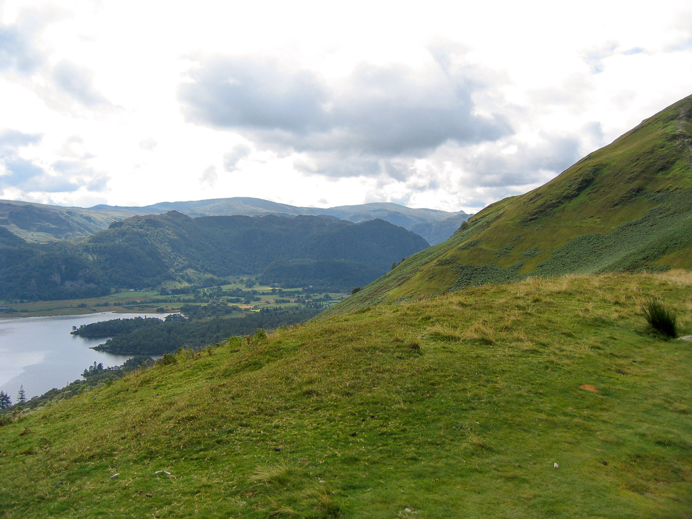
Mila and I with Derwent Water and Walla Crag and Bleaberry Fell beyond. The sunshine is glorious . . .


On Derwent Water we could see two islands; Mary Walsh in her book ‘North Lakeland Walks with Children’ explains that Otterbield Island – is the smaller island nearest to the foot of Catbells; and St.Herbert’s Island is the larger one just beyond and that this is the island Beatrix Potter’s Squirrel Nutkin and friends visit in nutshell boats with leaves for sails.


Being such a glorious day it wasn’t long before Mila took off her raincoat. We discovered that mint humbugs from the hotel were a fabulous walking incentive for Mila earning Mila the name, “Minty”!

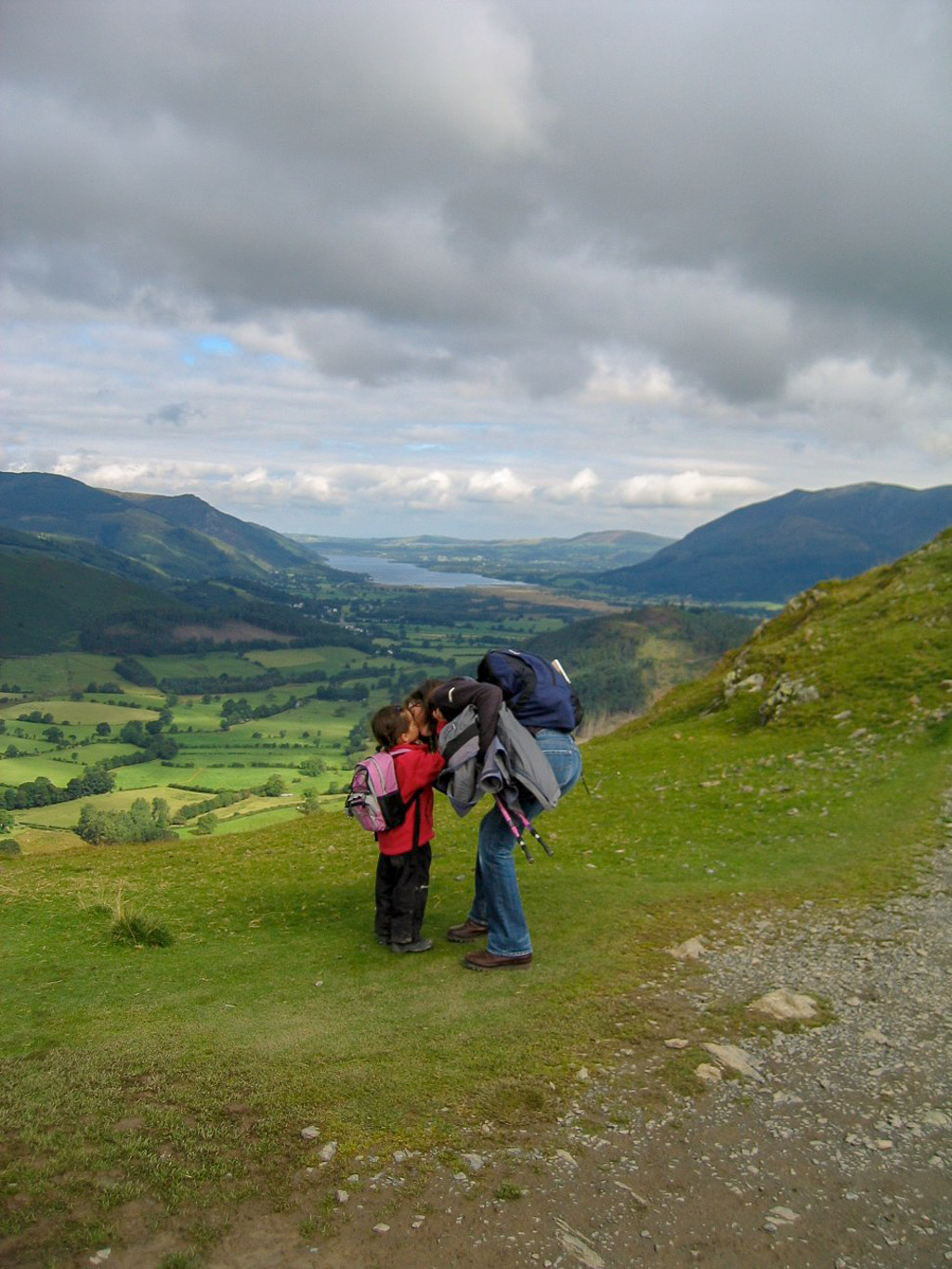
“Kiss Kiss . . . “

An easy engineered path to help prevent erosion to follow . . . with Derwent Water and the Northern fells in the background.

“Can I give you a hand Mila?” . . .” Not just now Pops!” (Walla Crag and Bleaberry Fell in the background).

“Go on then, you can give me a little help . . . but just a steadying hand . . . while I’m trying to whistle!”

A look back at the short steep section that entailed a brief scramble . . . Mila loved it.

Looking west over the Newlands Valley to Rowling End leading to Causey Pike with its very distinctive bobble summit.
The fells left to right: Ard Crags leading to Knott Rigg; Whiteless Pike; Sail; Scar Crags; Causey Pike; Outerside and the slopes of Barrow on the right. Grisedale Pike is lost under cloud.

A great view of Keswick beyond Derwent Water and Latrigg between the Skiddaw Massif (on the left) and Blencathra (on the right). With the north Pennines in the distance.

What could be better than this? . . .

The views are opening up all the time with the Newlands Valley laid out before us. I love the way the clouds create interesting shadows on the fells. Now you can see Grisedale Pike (the dark fell on the right beyond Outerside) coming into view.

Mila’s already a very confident walker – it’s only her parents who are nervous about her abilities!

Here we are on the stony top of Skelgill Bank with Skiddaw in the distance to the left of us – it feels like quite an achievement for Mila who, having grown up in Cambridge, is rather more used to the flat – not much in the way of hills around us back home!

There’s no stopping Mila now . . . and off she goes, heading for the summit. You can’t really see it in this photograph but to the left of us (on the right in the photo) the rock cuttings are the remnants of the upper workings of the Old Brandley Mine.
Youngsters are so affectionate aren’t they . . . so sweet . . . anyway, getting back to the views! This time Bassenthwaite Lake is beyond us with Lord’s Seat on the far left then Barf with Binsey; Dodd (dark and barely discernible in front of Ullock Pike. Swinside is just beyond my rucksack!

Despite this being a very popular route it was surprisingly quiet on our way up with only a few other walkers.
Isn’t this a glorious view of the Newlands Valley. Left to right: Maiden Moor with the ridge leading down to Knott End and Yewthwaite Comb and Newlands Church; then the dark summit of Dale Head; following the ridge along to Hindscarth and down Hindscarth’s ridge to High Crags then down Scope End. The next fell to the right is Robinson sloping down to High Snab Bank. Red Pike is the dark fell beyond, lost in cloud. Finally on the right are the slopes of Knott Rigg.

Mila and I as we’re nearing the final pull up to the summit of Catbells with Maiden Moor on the right.

Looking south to west: Knott Rigg; Ard Crags; Eel Crag; Sail; Scar Crags; Causey Pike; Grisedale Pike in the distance and Outerside in front of it (to the right of Causey Pike).

The perfect fell to be the first fell that Mila’s walked by herself. The summit is straight ahead and Miaden Moor and Hindscarth are to the right.
Looking east to south: beyond Derwent Water we have Grange Fell (the darker fell) with its three summits Ether Knott (the highest); then Brund Fell its next summit and the most visited of Grange Fell’s summits – the triangular shaped darkest part of the fell in this photo – King’s How (from which you get the best views). Beyond Grange Fell is Ullscarf and High Raise with Pike o’ Stickle being the little bump on the horizon (on the right before the green slopes of Catbells) with Rosthwaite Fell barely visible in front of it.


Across Derwent Water you have Walla Crag and Bleaberry Fell.

Mila is such great company . . . There’s always time to stop and talk . . .

Is Mila posing, or just having a little rest?

On the left you can see the escape route Mary Welsh mentions in her guide book if you need to shorten the walk, but for us . . . we’re heading up to the summit! (Grange Fell is to the left of Catbells here).

A close up of Maiden Moor (the summit of Dale Head is just out of sight beyond Maiden Moor); Hindscarth and Robinson with the Newlands Church in the valley below.

Wherever possible Mila would rather climb . . . why go the easy way?

Looking back . . . along the route we’ve followed up Skelgill Bank. There’s Bassenthwaite Lake in the background. Barf is on the left and the Northern fells of Binsey on the right in the distance and closer is Ullock Pike with the slightly pointy summit and along the ridge is Long Side then Carl Side and then on the far right are slopes of Siddaw. Dodd is in front of Ullock Pike, hard to distinguish here.

Not far now . . .

“Do I really need a hand here?”

What a view now, and you can see it’s getting much busier!

The final scramble up to the summit.

There’s no rush, we can just take our time.

“My little legs are getting a bit weary now.”

On the summit, a very satisfied Pal and Mila . . . I can see that Mila has already got her eye on her crisps!

This marks the start of the tradition of having Wheat Crunchies or Monster Munch crisps in our pack lunches in the Lake District, strangely we only ever have them in the Lakes!

Not a bad photograph of Pal and I by Mila!

Taking a moment to enjoy the views . . .

A close-up of the same photo – Mila is waving at me . . .

The main fells here are Knott Rigg and Ard Crags.

A very kind passing walker took this photo of the three of us (Maiden Moor and Hindscarth in the background).

Mila looking cool!

Ahead is the ridge leading to Maiden Moor but we’re going to leave that to another day and instead head down so that we skirt the bottom of Catbells making our route circular.

A clear path down.

Looking back at the busy route down.

You can see King’s How (Grange Fell) ahead. You can just see Castle Crag jutting up against the slopes of Catbells in the photograph below. Filling the valley gap you have: High Raise with Sergeant’s Crag in front then Rosthwaite Fell; Rosthwaite High Fell then Glaramara; Esk Pike and Allen Crags in front.

The Northern Fells in the distance.

Pal and Mila deep in conversation . . .

I wonder what they’re looking at . . .

Long now . . . down we go.

A beautiful Rowan tree with plenty of beautiful red berries, the birds will enjoy them . . .

Steady as we go.

On the way down we played hide and seek with Mila which she loved!

Found you! . . . Mila taking her turn at hiding.


Almost down now . . . Catbells summit in the background.

Bye folks, we’re almost back to the car now.

A great day . . . finished off with a visit to Abrahams – the cafe in George Fisher’s in Keswick. Mila loves this little play area under the stairs to the cafe, a perfect little den.